
Wauwatosa ZIP Directory Areas
Four postal areas account for nearly all primary residences in the city survey, but official Census geography also shows two more ZCTAs intersecting Wauwatosa. A ZCTA is a Census approximation of a postal service area, not an exact delivery boundary. The table therefore distinguishes strong local residence evidence from a mere geographic overlap. Use it to choose a likely starting area, not to declare that every address in a ZIP belongs to Wauwatosa.
| ZIP | Wauwatosa connection | Postal locality | Local evidence |
|---|---|---|---|
| 53213 | Core, central, and southern Wauwatosa | May appear as Milwaukee on some deliveries | 48% of surveyed primary residences |
| 53226 | Western and southwestern city, including the Watertown Plank area | Milwaukee postal operations; Wauwatosa accepted for qualifying addresses | 31% of surveyed primary residences |
| 53222 | Northern and northwestern Wauwatosa | Shared beyond the city | 12% of surveyed primary residences |
| 53225 | Small northwestern reach | Shared beyond the city | 7% of surveyed primary residences |
| 53208, 53210 | ZCTA intersections at the eastern edge | Milwaukee-area labels | Intersection does not prove city location |
The remaining survey responses, three percent after rounding, used other postal codes. That small share matters. A Wauwatosa property owner may receive tax mail elsewhere, and a resident may use a mailing address that differs from the physical parcel. The ZIP code directory must be paired with the situs address, meaning the place where the parcel is physically located. It should never be read as a complete roll of occupants.
Verify a Wauwatosa ZIP
The USPS ZIP Code Lookup has three different purposes. By Address standardizes one street address. By City and State returns ZIPs associated with a locality. Cities by ZIP reports locality names tied to one code. Only the first mode can settle the current delivery code for a specific house.
| Field | Input | Required | What it does |
|---|---|---|---|
| Street address | Text | Yes in address mode | House number and street |
| Apartment or suite | Text | No | Refines a multi-unit delivery |
| City and state | Text/select | Yes | Sets the postal locality |
| ZIP | Five digits | No in address mode | Checks a known code |
A standardized result confirms how mail is addressed today. It does not confirm that a named person or business occupies the site, and it does not draw Wauwatosa's legal boundary.
Wauwatosa Residents by ZIP
The 2018 city resident survey provides the most useful local comparison. ZIPs 53213 and 53226 together accounted for nearly four out of five primary residences in that response set. That makes them sensible first slices when only a broad area is known. The smaller 53222 and 53225 shares still cover meaningful parts of northern and northwestern Wauwatosa.
Percentages describe the survey, not a live resident count. They should not be applied to a name search as proof. Postal coverage changes at the address level, while the city survey reflects how respondents described their primary residence at one point in time.
Note: Confirm any current mailing code through USPS before recording it in family, estate, or reunion research.
Search Wauwatosa Residents by ZIP
A useful ZIP search moves from postal verification to parcel evidence. The city tax portal exposes owner and property-address searches, while WAGEO's parcel data includes a ZIPCODE field. MyVote uses a ZIP as one required part of address-based self-lookup, but it does not release a list of everyone registered within that code.
- Run the full address through USPS and note the standardized city, state, and ZIP.
- Open the Wauwatosa WAGEO viewer, locate the parcel, and compare its situs ZIP with its owner-mailing ZIP.
- Use the public parcel REST ZIPCODE field when a reproducible ZIP filter is needed. The service caps a response at 2,000 records.
- For your own registration, enter the complete address and ZIP in MyVote Wisconsin. Treat it as self-lookup, not a block roll.
Once the postal area narrows to a named road, the Wauwatosa street directory supplies the fuller address workflow. A ZIP-wide parcel result lists taxed land and owner fields, not every resident.
Wauwatosa ZIP Search Quirk
The city systems do not accept addresses in the same form. Basic instructions for the Wauwatosa City Tax Web Portal tell users to omit a directional prefix and street type. The GIS parcel record, by contrast, retains house number, street direction, name, type, ZIP, owner name, and owner mailing fields.
Try the short street name in the tax portal, then use the full mapped form in WAGEO. If an owner-mailing code differs from the situs code, keep both with clear labels. The first routes tax correspondence; the second locates the land.
The Wauwatosa City Tax Web Portal provides the local property-search entry point used to check a ZIP clue against a parcel.
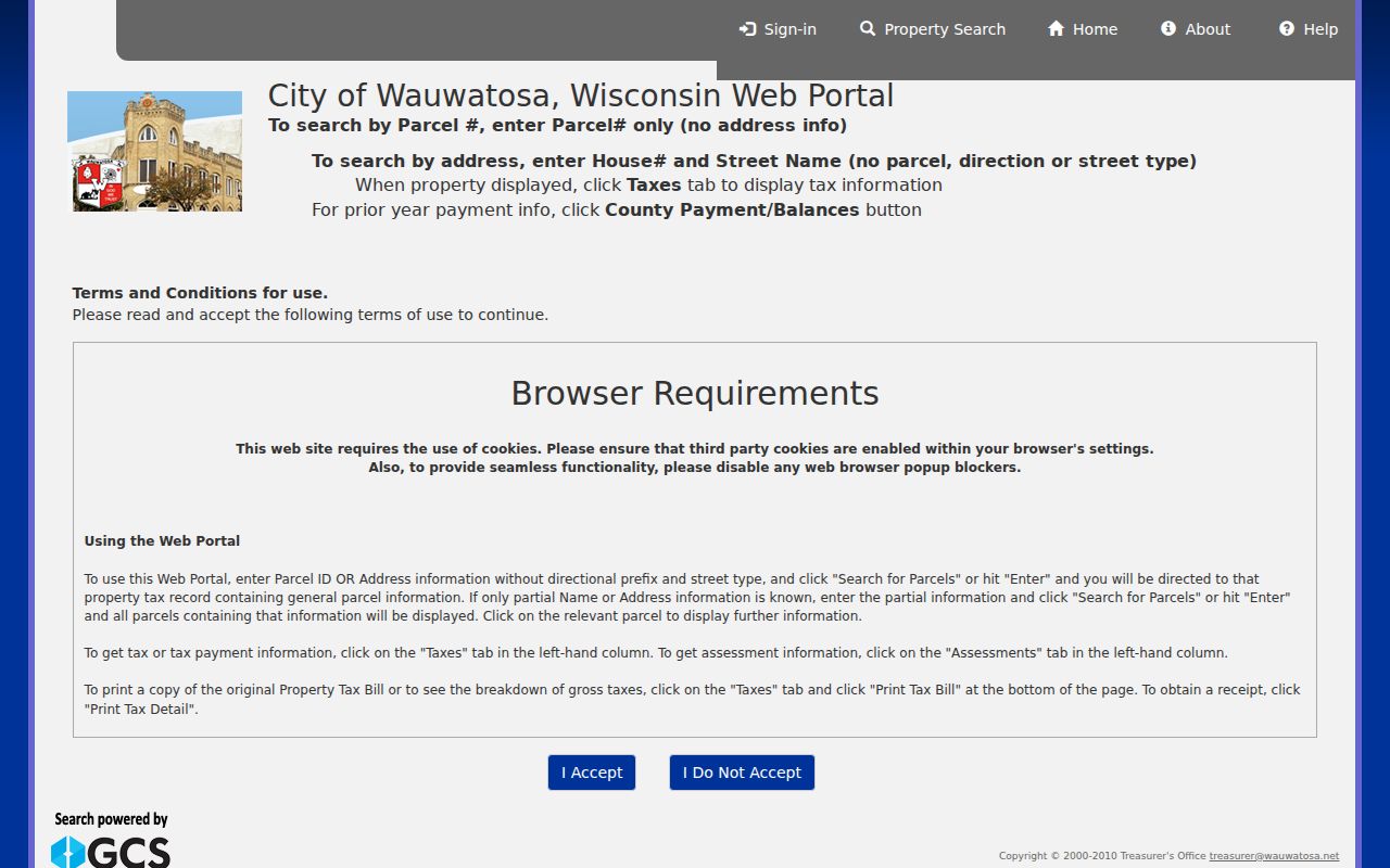
The captured portal shows why a postal search should move to a specific property record before any owner or resident conclusion is made.
Milwaukee Labels in Wauwatosa
Some valid deliveries within or near Wauwatosa can show Milwaukee as the postal city. USPS accepted-locality material recognizes Wauwatosa for qualifying addresses, yet the mail label is not a municipal jurisdiction test. Parcel boundaries, the legal description, and the city's map carry more weight when the question is whether land lies in Wauwatosa.
This mismatch also affects older records. The 1952 annexation changed the jurisdictional setting of former Town of Wauwatosa land. A person or address can therefore appear under Town of Wauwatosa, Wauwatosa, or Milwaukee in different sources without those records necessarily conflicting.
Wauwatosa ZIP and City Limits
ZIP areas are built for mail delivery. Wauwatosa's limits define municipal government. Census ZCTAs approximate where a ZIP is used for statistical work. Those three geographies overlap, but none can substitute for the others. This is why a 53208 or 53210 polygon touching Wauwatosa does not place every address in that code inside the city.
- ZIP and ZIP+4
- A ZIP is the five-digit delivery area. ZIP+4 adds a smaller delivery segment for more precise sorting.
- PO-box ZIP
- A code used chiefly for post-office boxes rather than ordinary street delivery.
- Unique ZIP
- A code assigned to one high-volume institution. None was established for Wauwatosa in the reviewed research.
- Carrier route
- A postal delivery path within a ZIP, not a city ward, district, or parcel boundary.
Boundary check. Use USPS for the delivery code and WAGEO for the parcel's city placement. Neither source identifies every person at an address.
Old Wauwatosa ZIP Clues
Historical address work starts before modern ZIP geography. Wauwatosa renamed and renumbered streets in 1931, and the 1932 city directory is a key bridge between old and current forms. The Milwaukee 1930 address-conversion book also preserves old-to-new examples. A modern ZIP search may fail simply because the house number has changed.
When an old address does not map cleanly, compare the printed directory entry with the historical-directory GIS fields FULL_ADDRE and MATCH_ADDR. Then verify the parcel by taxkey or legal description. That stable parcel identity is more useful than forcing a present-day postal code onto an early record.
Read Wauwatosa ZIP Results
A good result keeps three labels separate: USPS delivery city and ZIP, the parcel's physical situs, and the owner's mailing address. Agreement strengthens confidence that the records refer to the same place. Disagreement calls for a boundary check, not an assumption that one source is wrong.
The WAGEO parcel service can return owner names and mailing ZIPs alongside situs fields, but a single response is capped. Use a narrow filter and preserve the taxkey so another researcher can reproduce the parcel match.
Wauwatosa ZIP Portal Differences
The four main address systems organize Wauwatosa records in different ways. The city tax portal searches current and historical properties by parcel, owner, property address, public-land-survey details, and municipality. Its records include ZIP data, but its published instructions do not promise a ZIP-only resident list. The assessor comparison form is narrower. It asks for parcel number, a low and high house number, street name, street suffix, and assessment year. It does not expose a ZIP field.
WAGEO is the practical source for a parcel-level ZIP filter because the public schema includes ZIPCODE along with house number, street direction, street name, street type, and full address. A REST query can return those fields with owner and owner-mailing details, but it returns parcels. One apartment parcel may contain many people, while a vacant or public parcel may contain none. The service also limits a result to 2,000 records, so a broad response should be narrowed and checked for truncation.
MyVote uses a five-digit ZIP in its address mode with house number, street name, street type, city, and state. That search is meant to resolve an individual registration or polling-place question. It does not let a casual visitor download everyone in 53213 or any other Wauwatosa postal area. A separately requested Wisconsin voter file is governed by Wis. Stat. §6.36 and has its own access and privacy rules.
When Wauwatosa ZIP Search Fails
Try the source that answers the specific question. For a current delivery code, use USPS By Address. For a city-boundary question, locate the parcel in WAGEO and compare the municipal layers. For an ownership clue, inspect the city tax record. If a portal cannot find the address, remove the directional prefix and street type in the tax search, then try the complete street form in GIS. Search the parcel number or taxkey when text still fails.
Older addresses require a different fallback chain. Consult the 1930 conversion book or 1932 directory, test the historical and current street forms in the Planning historical-directory layer, and confirm the match in an original directory volume. Wauwatosa Public Library and the Historical Society can help when the needed volume or conversion detail is not online. For an existing city record not published through a portal, Wisconsin Public Records Law provides a request route through the responsible city custodian.
Do not force a postal conclusion from a property owner's correspondence address. The OWNERZIP field belongs to the owner-mailing record, while ZIPCODE belongs to the situs. Labeling each field prevents an out-of-area mailing destination from being counted as a Wauwatosa residence.